PREDICTION OF GLACIAL HAZARDS AND DISASTERS IN THE CENTRAL CAUCASUS, RUSSIA

Main project page

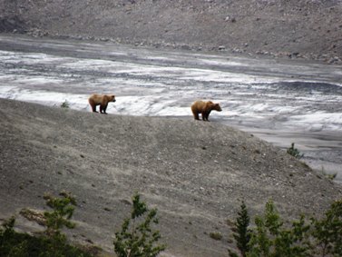
Field training project: Glacial Lake Melbern, British Columbia, Canada

Background

As noted in the newly released IPCC report (IPCC, 2007) on climate change, glacier retreat and the associated formation of glacial lakes have recently been observed throughout mountainous regions of the world. Recent glacier ice loss in British Columbia has been documented in a recent paper by Schiefer et al., 2008. The project aims to document dramatic changes of glacier and lake extent in the St Elias Mountains of British Columbia, along the Alaska-Canada border, by comparing modern data with the record of the International Boundary Commission (IBC) maps surveyed in 1906-1912, a source of detailed mapping made one hundred years ago. This mapping record is unique for the mountains of North America.

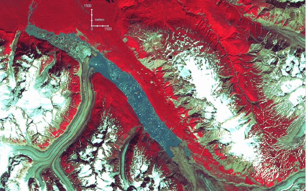
Location and setting of Lake Melbern showing Konamoxt and Melbern Glaciers, St Elias Mountains, British Columbia

A casual scan of contemporary satellite imagery shows dramatic ice loss and associated development of Lake Melbern, currently one of the largest glacial lakes in North America. Little work has been done with regard to the ice loss for Melbern and Grand Pacific glaciers (Clarke and Holdsworth, 2002) and formation of glacial lakes in the region, with the exception of a paper by Clague and Evans (1993).

The objectives of the project are four-fold: 1) to assess the influence of climate change on the formation of one of the largest glacial lakes in North America - Lake Melbern, 2) to document the rate and style of development of Lake Melbern, 3) to define the outburst flood/debris flow hazard associated with the current status of Lake Melbern, and 4) compare the results to similar results obtained in the Caucasus Mountains, Russia, a region also subject to dramatic glacier ice loss.

The development of Lake Melbern is being documented using the early 20th century IBC maps as a starting point, followed by the analysis of successive aerial photographs (1948-present day) and satellite imagery (1972-present day). Contours and glacier boundaries are being digitized from the maps to derive the areal extent and surface elevations of Melbern and Grand Pacific glaciers in the early 20th century, and later imagery has been processed to derive comparable data for later dates to the present. These datasets are georeferenced and combined in a Geographic Information System (GIS) environment to map out the extent, volume and rates of the glacier ice loss and changes of lake area and volume. We thus have roughly a century of documentation of glacier change and lake development in this area of the St Elias Mountains.

Objectives

The objective of the field training will be to develop and apply methodologies of characterising the rate and extent of glacial lake development due to catastrophic glacier ice loss. During field training under this project, the elevations of current and former shorelines will be recorded with an 
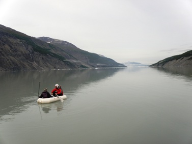
altimeter in field traverses. Depth sounding in safe near-coastal areas of Lake Melbern will be attempted. Survey triangulation points of the IBC will be re-occupied and repeat photography and topographic measurements will be carried out. Geomorphological mapping within Little Ice Age limits will also be undertaken at a scale of 1:50,000. We will also assess the stability of the existing outlet of Lake Melbern with respect to outburst potential.

Following fieldwork the change detection analysis have been completed. Present depth and volume of Lake Melbern have been derived using depth measurements, which extrapolated using the features of the valley topography.

In the final stage, change detection results will be compared against climate data to determine possible links with regional climate change. Rates of glacier ice loss and glacial lake development for Lake Melbern will be compared with these for the Central Caucasus Mountains, Russia, where similar data has already been obtained for some glacial lakes (Petrakov et al., 2008).

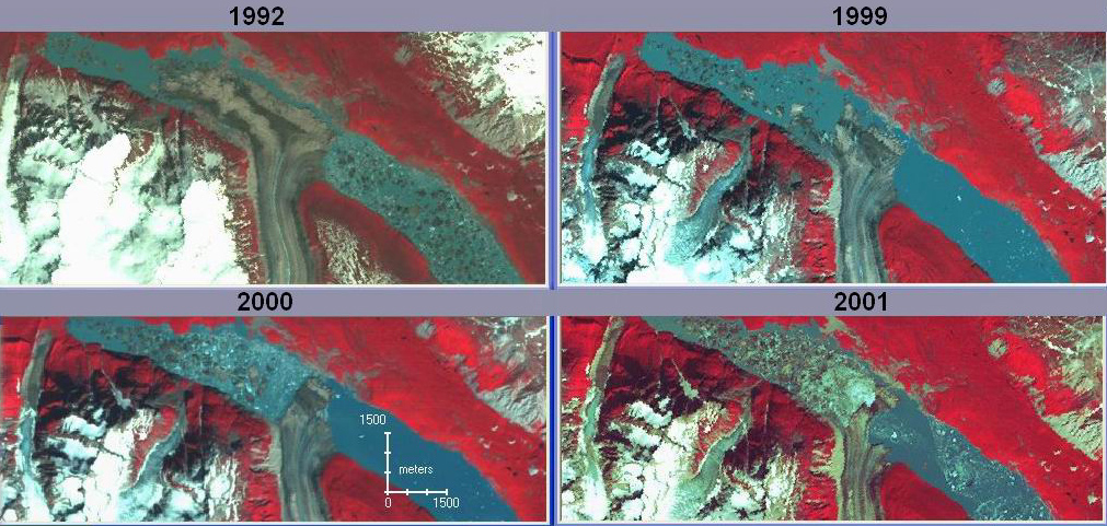
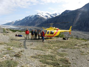
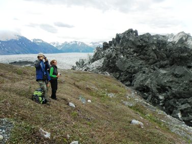
Development of Lake Melbern 1992-2001 (Landsat TM/ETM+ imagery).

Field training in Canada

This key activity was organised by Prof. S.G.Evans for the Russian teams and took place on 12-29 August 2008 in Canada. The Russian group (Chernomorets, Petrakov, Tutubalina, Kargapolova, Shakhmina) have started by meeting the outgoing Co-Director Prof. Hungr in Vancouver, and then moved to Whitehorse on the same day together with the NPD Professor Evans. After some preparation, the UW-UCEGM-MSU team was brought to Lake Melbern in St Elias Mountains by helicopter and began core field training activities, which continued until 25 August. The research goals of this training were to document dramatic changes of Melbern Glacier and Glacier Lake extent in the St Elias Mountains of British Columbia, along the Alaska-Canada border, by comparing modern data with the record of the International Boundary Commission (IBC) maps surveyed in 1906-1912, a source of detailed mapping made one hundred years ago. This mapping record is unique for the mountains of North America.

In the field, the elevations of current and former shorelines were recorded with an altimeter in field surveys. Depth sounding of Lake Melbern was successfully conducted, in a special inflatable boat, designed by Ivan Krylenko (Moscow State University) on the basis of previous field experience in the Caucasus glacial lakes. Photostations were established and located with a GPS to enable future monitoring of fast-growing Lake Melbern for decades ahead. During a helicopter overflight, the stability of the existing outlet of Lake Melbern was assessed with respect to outburst potential.

The team also undertook observations at the surging Tweedsmuir Glacier which threatens to dam the Alsek River, which could result in a temporary lake and a subsequent outburst, possibly flooding Alaskan coastal villages. The research was conducted in challenging terrain and in the bear country but went smoothly due to the thorough organisation of the field activities. The Iridium satellite phone, acquired in summer 2008 through the project was of critical importance in this field expedition.

Valuable skills were gained by the Russian teams as a result of this training, and at list one major research paper is planned for an international peer-reviewed journal as a result.


Field training in Canada in August 2008. Team arriving by helicopter at Lake Melbern field camp


Bathymetric survey of Lake Melbern by Petrakov and Kargapolova


Grizzly bears encountered on a field traverse


Observations at the surging Tweedsmuir glacier

Personnel

Six project participants attended the Canada field training:
Prof. Stephen G. Evans (NPD)
Dr. Sergey Chernomorets (PPD)
Dr. Dmitry Petrakov (Co-Director)
Dr. Olga Tutubalina
Dr. Irina Kargapolova
Ms. Marina Shakhmina

Visits

University of British Columbia (Vancouver, British Columbia)
Yukon Geological Survey (Whitehorse, Yukon)
Tatshenshini-Alsek Provincial Park (Haines Junction, Yukon)
Kluane Lake Research Station (Kluane Lake, Yukon)

References

Clague, J.J., and Evans, S.G., 1993. Historic retreat of Grand Pacific and Melbern Glaciers, Saint Elias Mountains, Canada: An analogue for decay of the Cordilleran ice sheet at the end of the Pleistocene? Journal of Glaciology, vol. 39(133), p. 619-624.

Clarke, G.K.C., and Holdsworth, G., 2002. Glaciers of the St Elias Mountains. Satellite Image Atlas of Glaciers of the World-North America, United States Geological Survey Professional Paper 1386-J, p. J301-J312.

Intergovernmental Panel on Climate Change (IPCC), 2007. Climate Change 2007: The Physical Science Basis. WMO-UNEP.

Petrakov, D.A., Krylenko, I.V., Chernomorets, S.S., Tutubalina, O.V., Krylenko, I.N., and Shakhmina M.S., 2007. Debris flow hazard of glacial lakes in the Central Caucasus. C.-L.Chen & J. Major (eds). Debris-Flow Hazards Mitigation: Mechanics, Prediction, and Assessment. Rotterdam: Millpress, 2007, p. 703-714.

Schiefer, E., Menounos, B., and Wheate, R., 2008. An inventory and morphometric analysis of British Columbia glaciers, Canada. Journal of Glaciology, vol. 54, p. 551-560.


Хостинг от uCoz