Report on conference and field training mission to Peru 5-20 March 2007 Summary In our SfP
proposal we targeted attendance at the 2nd
Alexander Von Humboldt Conference in Lima as a project
priority. The conference on The Role of
Geophysics in Natural Disaster Prevention was
held in Lima, Peru (http://www.igp.gob.pe/avh2_loc/) on March 5-9. The conference
served as a major forum in which to outline our project
to the international community and to report on project
results so far. Two oral presentations were given and
attracted much professional interest: by Dr. D. Petrakov,
outlining the unique features of glacier disasters as a
special type of glacial hazards, and by Dr. I.
Kargapolova on river channel dynamics in the context of
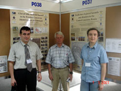
climate change. A poster summarizing our project and a
second one on project results were presented in a poster
session by Dr. S. Chernomorets and Dr. O. Tutubalina. A
number of visits and useful research contacts were made
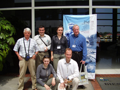
in Lima. Personnel Five project participants have attended the Lima meeting and the field training in Huaraz. They are:
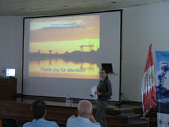
Additionally a representative of our end-user Dr. Eduard Zaporozhchenko (Sevkavgiprovodkhoz Institute, Pyatigorsk, Russia) took part in this mission together with us but on his own funding. 2nd Alexander von Humboldt (AVH2) conference The following four presentations were delivered (name of the presenter/author in attendance in bold):
Dr. Petrakov’s oral presentation on glacier disasters initiated lively professional interest. One of the reasons can be that Peru has experienced such events (Mt Huascaran area, 1970, 1962 and prehistoric events. This and poster session discussions resulted in several useful professional acquaintances.
Business visits in Lima These included visits to several institutions involved with geohazards research in Peru: INGEMMET
(Sector Energia y Minas; Instituto Geologico
Minero y Metalurgico, Av. Canada No1470, San Borja Lima
41 - Peru – Apartado 889). The visit to
this institute, which Professor S.G.Evans previously
visited in 2004, started with an excursion, talks with
the Executive director Dr. Jose Machare Ordonez, and
provision of support letters for subsequent field
training in the Ancash region. It continued by detailed
examination of geomorphological maps for the Ancash
region in the section of environmental geology (Geologia
Ambiental), as presented by Ing. Patricio Valderrama and
Ing. Lionel Fidel. Twelve members of the institute have
joined the Debris Flow Association, an international
professional body founded in Russia in 2005, where Dr.
Zaporozhchenko currently serves as a Vice-President, and
Dr. Chernomorets as a Scientific Secretary. Maps and
materials on geohazards were exchanged and further
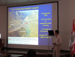
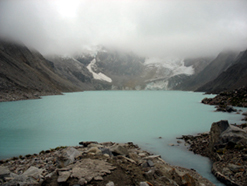
contacts agreed upon. Business visits in Huaraz INRENA (Instituto Nacional de Recursos Naturales, Unidad De Glaciologia y Recursos Hidricos, Avda. Confraternidad Internacional Oeste #167, Huaraz - Peru). Meeting head of the glaciological unit Ing. Marco Zapata and his workers Nelson Santillan and Jesus Gomez. Exchange of research materials on glacier disasters and outburst-prone lakes. Joint field trips to Paron and Lake Llaca, getting acquainted with the engineering protection measures installed on local glacial lakes, as developed with participation of INRENA. Agreement to continue joint work in the named fields. HUARAZ II hospital. This hospital has been created with the help from USSR experts during the rescue work after the catastrophic earthquake of 1970, which destroyed much of the Ancash region and led to a glacier disaster at the foot of Mt. Huascaran, burying the town of Yungay and several villages. Visit to the monument in the memory of Soviet rescue workers, medics and pilots who perished in 1970 over the Atlantic en route to Peru. Meeting hospital director Dr. Guillermo Milla Meza. Field training schedule 11 March.
Arrival to Huaraz.
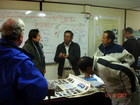
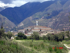
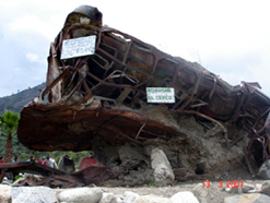
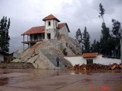
Visit to INRENA. Dr. M. Zapata and his team explain their current research in Cordillera Blanca to the project team 13 March. Field visit to the village of Ranrahirca (destroyed by glacial events in 1962 and 1970) and the memorial in the former place of the town of Yungay (destroyed in 1970; 18,000 victims). Inspection of debris flow deposits. Walk around the Yungay memorial, purchase of literature about the event, GPS measurements, and examination of the debris. Inspection of the path of the 1970 event, including the section where part of the mass run up the slope and then fell off onto the town of Yungay. Locating boulders which might have been a part of a pre-Columbian rock avalanche from Mt. Huascaran, that probably reached further than the 1970 event and crossed the Santa River.
14
March. Field visit through Yungay to the Lakes
Llanganuco and the Puertas al Cielo mountain pass. Visit
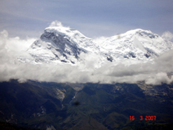
to the memorial dedicated to mountaineers who perished in
the area, including a Czech group killed during the
Huascaran glacier disaster on 31 May 1970. It was
established that the famous photographer Vilem Heckel, a
member of the group, took photos of the Mt. Huascaran
summit for the Llanganuco lakes area; therefore a north
face of the mountain was pictured, which unfortunately
does not give many clues into the pre-disaster conditions
in 1970 (the main mass of ice fell of the western side).
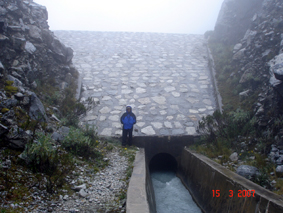
Protective dam on Lake Llaca 16 March.
Taking advantage of the first day of sunny and clear
weather, we had a field visit to the Cordillera Negra
ridge opposite Mt Huascaran to repeat photographs of 1970
and assess the extensive resettlement on the 1970 debris
flow deposits. Then work was continued in two groups:
group 1 (Evans, Chernomorets, Tutubalina, Zaporozhchenko)
continued photography of the Yungay site, then went to
see the installations of the Canon del Pato hydroelectric
stations and traces of the 1970 debris flow (which
destroyed some of the road tunnels and the hydroelectric
dam); group 2 (Petrakov, Kargapolova) went to Lakes
Lllanganuco to repeat photo of the summit of Mt Huascaran
made by Vilem Heckel and later developed as his camera
was found in the avalanche debris (a biography of this
outstanding photographer and mountaineer is available at http://stityheckel.cz/en.php?st=VilemHeckelCuriculumVitaeEn). In the evening we had another
meeting with Marco Zapata’s group and it was decided to
prepare collaborations of agreement between his group and
Russian and Canadian teams.
18
March. Field trip to headwaters of the Santa River
and along Cordillera Blanca. Inspection of a fresh
landslide on the road to Chavin de Huantar. Outcomes of the Peru mission Topics discussed during this mission were written down as the Huaraz Memorandum, which covered research articles to write, involvement of new young scientists, preparation of an Advanced Research Workshop on Glacier Hazards, international research cooperation, schedule for preparation of the 6-month SfP project report, further funding of joint work, improvements on the project website and further collaboration within the project. |
||||||||||||||||||||||||||||||||||||||||||||||||||||||||