 |
|

| PREDICTION OF GLACIAL HAZARDS AND
DISASTERS IN THE CENTRAL CAUCASUS, RUSSIA Main project page
|
Glacial hazards research and monitoring:
first and second years of the project
Mountain
glaciers are among the most spectacular features of
alpine landscape, a target for recreation, and an
important freshwater source, especially for some arid and
semiarid regions. However, they also bring destructive
natural hazards. Global warming leads to dramatic and
accelerating shrinkage of alpine glaciers around the
world since the end of the Little Ice Age (mid-19th
century), and most glaciers have retreated by up to a few
kilometers. After the termini of the glaciers retreat the
vacant areas are occupied by moraine (glacier-created)
debris and proglacial lakes, usually dammed by unstable
moraines or stagnant ice. In comparison with other
glacier hazards, glacier lake outburst floods (GLOFs) are
most widespread and highly recurrent. The deadliest GLOF
happened in Huaraz, Peru in 1941 and killed about 5000
people. In the Alps up to 60% of the victims of glacial
hazards were killed by GLOFs and consequent debris flows.
In summer 1998 an unexpected GLOF in Kyrgyzstan and
Uzbekistan (Central Asia) killed over 100 people.
Frequency of GLOFs is increasing in the majority of
alpine ranges worldwide. Rate of proglacial lake increase
could be quite high, with their diameters growing by some
hundred meters per year in extreme cases. Often local
population learns about the very existence of a
proglacial lake after it has produced GLOF event.
Location and size of new lakes, their current state and
hazard potential could shift rapidly. In combination with
rapid growth of population and economic development it
means a high GLOF hazard for communities downstream of
the lakes. Regular monitoring of periglacial environment
is needed to identify most vulnerable zones, reduce and
mitigate GLOF risk, prevent life losses and minimize
economic losses.
All of the above is true for the Caucasus, a highly
glaciated mountain range up to 5642m a.s.l. set between
the Black Sea in the west and the Caspian Sea in the east,
between Russian in the north and Georgia & Azerbaijan
in the south. In the last 20 years glacial hazard
assessment here was scarce due to the difficult
transition period in the 1990s and the resulting lack of
funding. Early in the new millennium unpredicted glacier
hazards caused over 100 casualties, significant economic
losses (about 100 million Euro) and brought tensions
between the suffering local population and authorities in
the Russian Central Caucasus. Glacial hazard assessment
in the region was badly needed.
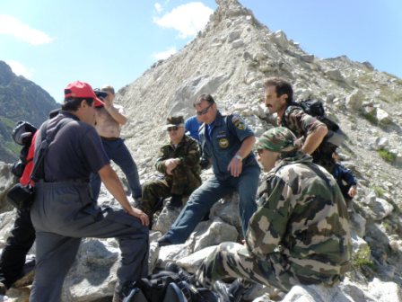
With enthusiastic support of the Ministry of Emergencies
offices in the Kabardino-Balkaria and Northern Ossetia-Alania
Republics, an international consortium of scientists from
Moscow, Russia, and from Waterloo and Vancouver, Canada,
have started a project on PREDICTION OF GLACIAL HAZARDS
AND DISASTERS IN THE CENTRAL CAUCASUS, RUSSIA, supported
by the NATO SfP Programme. Since in the near future GLOF
events are expected to make the main contribution to
glacial hazards in the region, one of the first tasks was
to identify most dangerous objects by making a regional
proglacial lake inventory. About 70 proglacial lakes were
identified in the Central Caucasus, some of them
potentially hazardous. A map of debris flow and glacial
hazards for the region has been also compiled.
Further work was directed in three main areas. Firstly,
two key areas of progalcial lakes, to the north of Mt.
Elbrus (the upper Malka River valley) and 20 km south-east
of Mt Elbrus (the Adyl-su river valley), were researched
as the most hazardous areas. Lake area increased there by
3 to 6 times in recent decades. A GLOF in the first area
was successfully predicted by the project team, helping
to avoid casualties. The hazard in the second area is
still growing, and a monitoring and early warning system
is operating there since 2008.
Secondly, a summer service of “debris flow and glacial
hazard watch” was organized for the Russian Central
Caucasus: from 2006, project end-users and local
authorities receive timely information from the project
field teams in June-September, with regard to current
level of the hazard; field teams investigate fresh debris
flow deposits and made short term hazard forecasts.
Thirdly, the project teams are maintaining monitoring of
the site of Kolka Glacier catastrophic event (which
killed over 125 people in 2002 due to a sudden glacier
collapse), advising local residents and authorities on
the current hazardous processes and build-up of new
glacial material in place of the former glacier.
In terms of reducing the current hazard, the project work
at key sites of proglacial lakes has been perhaps the
most significant.
The first site is in a wilderness area just below the 3-km
glaring-white north wall of Mt. Elbrus, the highest
mountain of Europe (5642 m a. s. l.). The lakes near
glacier boundaries are on a high plateau above the
semiarid mountain steppes of the foothills. Rich herds
are grazing upon the steppes. Local thermal springs
bubbling a few kilometres downstream of the proglacial
lakes are well-known in the Caucasus. Mountain dwellers
attribute miraculous curative qualities to these waters,
and hundreds of them come every year to bathe in little
stone pools, erected right on a floodplain at the
confluence of Birdzhaly-Su and Kizilkol rivers, with a
view to 25-m high Sultan waterfall.
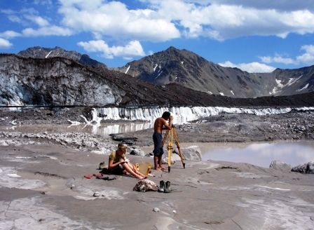
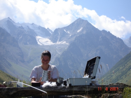
In 2006 the project team was measuring water volume in
proglacial lakes, and assessing GLOF hazard and risk-prone
zones. Rainy and foggy weather and icy mornings
accompanied the expedition which did not seem to find
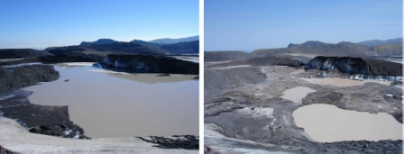
high hazard. However, when the last and largest lake was
surveyed, unalarming news was broken: the 400,000 cubic
meters of lake water were nearly overflowing its ice dam,
with only an 80-centimeter high icy barrier above the
water still keeping the lake in place. The trajectory of
the future outburst flood was clearly along the Birdzhaly-Su
River, straight through the thermal pools, where up to 50
people could be in the hazard zone. The GLOF was nearly
imminent: the project team concluded that it will happen
within two weeks given the regional melt rates for
glacier ice, the values well known to the project team.
The local administration, the Ministry of Emergencies and
the regional government were warned, and when the GLOF
did happen exactly 5 days later, there were no casualties,
though the pools were thoroughly destroyed and buried by
2 meters of mud and boulders. The lake which produced the
GLOF was nearly emptied; monitoring visits in 2007 and
2008 identified that despite the current growth of the
lakes none of them as yet presents significant hazard.
The second site of a potential GLOF is located in the
Adyl-Su valley in the southern part of Mt Elbrus region.
A group of proglacial lakes has formed in the headwaters
of Adyl-Su river catchment area, near the margin of
Bashkara Glacier. The biggest lake, called Bashkara, was
almost stable in size for many years, and its GLOF hazard
was assessed as medium. Since 2007 the glacier dam below
the lake has been actively degrading, and in 2008 the
seasonal lake level rise was much higher than normal.
This can result in a GLOF and a devastating debris flow
downstream (a similar event occurred at this site in late
1950s).
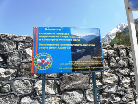
To reduce the risk the project team installed a self-designed
automatic early warning system. In case of sudden drop of
the lake level a siren is activated giving about 20
minutes warning. In addition, four warning poster boards
were established on the trails and at the camp site in
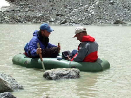
the danger zone. The project team also started constant
observations of the lake, and provided real-time
information in response to numerous calls from the
Ministry of Emergencies, local authorities and citizens.
By mid-July water started to overflow the dam started and
outburst probability became very high. Close cooperation
with the Ministry of Emergencies and local authorities
led to good awareness of mountain dwellers and tourists.
One of hotels was closed, the Ministry of Emergencies
received daily hazard assessments and brought its own
observers on the site. Luckily, the overflow stream has
stopped and in the end of August the situation was
stabilized.
Unique data and experience were obtained by this first
monitoring and early warning system for GLOF hazard in
Russia. The system has been designed and successfully
applied, and will be deployed again in the operational
mode in 2009.
Dozens of students have been trained during the project
both in the field and in the laboratories. Three students
obtained their PhDs during the project and three more are
working on their PhDs.
Glacial hazard assessment is an important contribution to
population security in alpine regions. Within the
framework of this NATO SfP project the assessments have
been made for the Russian Central Caucasus, but for many
other regions of the world glacial hazard these
assessments are badly needed. In poor mountain regions
economic and life losses caused by natural hazards are
often assessed by dwellers as inability of authorities to
improve their life, sometimes leading to tensions and
even separatist tendencies. Therefore environmental and
political securities are closely linked.
Glacial environment is possibly the most rapidly changing
landscape of the globe, so hazard assessment has to be
repeated at least each 3 to 5 years. This can be helped
by latest technologies, such as interpretation of very
detailed satellite imagery, and by training of local
experts and young scientists in such SfP projects as the
one exemplified above.
Further information is available at the project website
at
http://glacier-hazard.narod.ru/sfp.htm
|
|
|
 |