Bashkara glacial lakes (North Caucasus, Russia) and outburst hazard The Bashkara group of glacial lakes with a total area of 93,000 m2, and a total volume over 900,000 m3 is located in the upper part of Adyl-Su basin at the margin of Bashkara glacier (Fig.1).
Figure 1. Bashkara lake group. 1 – Bashkara Glacier, 2- Lake Bashkara, 3 – Lake Lapa, 4 – Lake Mizinchik. Photo by V.V. Krylenko. This valley-type glacier is roughly
4 km in length and has an area of about 3 km2.
The main branch of the glacier flows from Mt. Ullukara (4302
m a.s.l.) to the north and turns to the northwest at the
snout. A secondary branch issues from a mountain pass
between Mt. Bashkara (4164 m a.s.l.) and Mt. Dzhantugan (4012
m a.s.l.). This branch descends towards the northwest and
flows into the main branch in the upper part of the snout.
During the Little Ice Age (LIA) the glacier snout was
divided in two parts as a result of the main Ullukara
branch pushing the Bashkara branch out to the right side
of the valley. As a result, a moraine ridge loop was
created. In late 1940s - early 1950s Lake Bashkara
started to form inside the loop due to the stagnant ice
melt. The lake was not shown on a schematic map of the
Bashkara glacier in 1933 (Oreshnikova 1936), and did not
yet exist in 1946 (E.A. Zolotarev, pers. comm.). However,
it was shown on a 1957 schematic map (Dubinsky &
Snegur 1961). At that time the lake area was two times
less than today. A second smaller lake downstream of the
glacier snout is also mentioned in the literature. In
August 1958 and 1959 Lake Bashkara burst through its ice
dam. After these GLOFs the level of the lake was lowered
by two meters. The smaller downstream lake was also
involved in the flood. As a result catastrophic debris
flows totalling 2 million m3 were formed from
the moraine deposits and travelled 12 km downstream. The
initial water impulse was only 60,000 m3 (Seinova
& Zolotarev 2001). Lake level dynamicsWater level of a glacial lake is
one of the most important indicators of short-term
outburst hazard. Lake Lapa is drained by a well-developed
runoff channel, so the water level variations are not
large. During summer the range of variations is about 10-15
cm, while the seasonal range does not exceed 30 cm. The
interannual lake level is also stable.
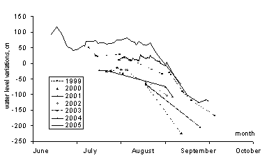
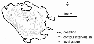
Figure 2. Lake Bashkara water level dynamics during warm periods in 1999 –2005. Zero level refers to the zero mark on the permanent level gauge. Changes in lake areas and volumesWe observe that Lake Bashkara is quasi-stable whereas Lake Lapa is drastically expanding. Area and volume of Lake Bashkara are driven mainly by level fluctuations and vary within 60,000-70,000 m2 and 675,000-800,000 m3. Below the zero mark on the permanent level gauge, the volume varies annually within a range of 750,000-790,000 m3 which, we note, is within the measurement accuracy. The maximum measured depth (34 m) in the centre of the lake (Fig. 3). is also stable, so the lake bed relief is assumed stable during the observation period.
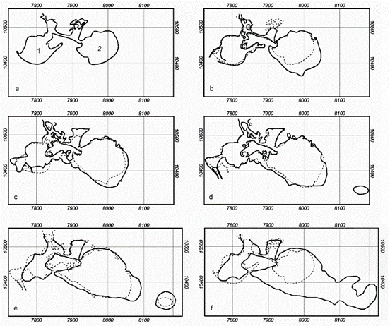
Figure 3. Bathymetric map of Lake Bashkara. Dynamics of Lake Lapa area and volume is presented in Fig. 4a. In 2001-2006 the lake area increased three-fold and the volume multiplied by a factor of five. The process is driven by the glacier terminus retreating from the eastern lake shore. The eastern part of the lake has maximum depths and features the most rapid shore recession (Fig. 4b & 5). The most intensive volume expansion was observed in 2002-2003 due to a depth increase and in 2003-2004 due to a notable enlargement of deep areas. In 2005 volumetric increase slowed due to depth stabilization, but in 2006 it accelerated as the lake merged with a very large thermokarst hole in the glacier. Average lake depth has been reduced due to sedimentation on the lake bed. The maximum depth increased two-fold in 2001-2002, was quasi-stable from 2003-2005 and decreased by 1 m in 2005-2006.
Figure 4. Lake Lapa: a - lake area and volume in 2001-2006; b - bathymetric map in 2006. In 2001
Lake Mizinchik was comparable to Lake Lapa in area and
volume. In summer 2001 transformation of the Bashkara
river outlet initiated rapid sedimentation in the lake.
Part of the glacier terminus adjacent to Lake Mizinchik
has been stable in recent years. As a result the lake in
2004 was only 25% of its size in 2001. In 2005 we could
not perform depth sounding of Lake Mizinchik because it
was too shallow for measurements. By 2006 Lake Mizinchik
had practically disappeared (Fig. 5).
Possible scenario and consequences of lake outburstThe condition of the ice and
moraine dams in the Bashkara area is constantly changing.
This makes it difficult to define the scenario of a
possible outburst and to calculate its parameters. To
assess features of a possible outburst flood, as well as
the discharge and volume of the resultant debris flow we
applied the method of geographical analogy. We reviewed
descriptions of ten GLOFs in Northern Tian Shan and
Dzhungarskiy Alatau mountains published in Russian
journals Selevye potoki (Debris flows) and Meteorologia
i Gidrologiya (Meteorology and Hydrology). The
case which is likely similar to the Bashkara lake group
was an outburst of a lake group in the vicinity of the
Tushinskiy Glacier of the Dzhungarskiy Alatau range on 8
September 1982 (Tikhomirov & Shevyrtalov 1985). The
volume ratio between the large upper lake and the two
small lower lakes, and the longitudinal profile of the
valley were similar to the Bashkara group. The event also
happened on the background of glacier recession. In late
August – early September the lake drainage channel was
blocked due to ice failure. On 8 September 1982 a break-up
of the ice plug led to the lake outburst. The level of
the upper lake dropped by 3.5 m, the lower lakes were
overrun and their dams rapidly eroded. The outburst had a
peak discharge of about 150 m3/s, which
continued for 1.5 hours. Within 1100 m downstream the
flood transformed into a debris flow having a peak
discharge of about 290 m3/s. When the debris
flow reached a steep moraine terrace (up to 12.5 km path
distance from the lakes) it transformed into a disastrous
mud-debris flow having a discharge of about 2400 m3/s
and a volume of 2.7 million m3. |
|||||||


